But
the setup was promising. The nose of a 60 to 70 knot jet streak at 250mb was wedging
its way into West Texas, and the shear profile looked at least moderately supportive of
supercell storms. As has seemed the case so many times this year, the mid-level
winds were very weak, and so I expected HP storms if I was lucky. A surface low deepened
in Eastern Colorado and both the ETA and RUC models represented the dryline moving
into the West Central Texas Panhandle regions. The MM5 model had a CAPE bullseye of
between 2000-2500 j/kg near Amarillo which was also on the north end of a good theta-e
ridge. There looked to be fair convergence from the surface up to 850 mb.
Storm-scale rotation would have been a pleasant surprise and tornadoes didn't really enter
my mind. The next day's setup looked potentially more promising and so I
rationalized that I was simply getting a head start on tomorrow's chase. With my
expectations sufficiently lowered, I left Denton at 9:00 AM.
Pick a Storm--any storm
Near Wichita Falls at 10:51 I encountered two brief showers which undoubtedly
formed on outflow boundaries from the previous night's convection. Old boundaries
would be a theme for the two day chase and would give me a new level of respect for the
role of the mesoscale in severe storm initiation and intensification. At 1:00 PM, I
stopped to eat in Childress where Glenn Dixon caught up
with me and we chatted on the radio. Glenn believed the better shear was in Eastern
Colorado and ultimately planned to go there with a data stop in Amarillo to see how things
were unfolding. At 3:00 we were in Amarillo looking for a place to connect Glenn's
laptop. Meanwhile, storm fired near the rim of the Palo Duro Canyon in response to a
warm front moving north and was visually impressive at that time with an overshooting top
and a backsheared anvil. The storm was moving Northeast away from the dryline,
trying to tempt me away from my target area. A data check showed the dryline moving
into the Panhandle right on schedule, and perhaps more instability in the area than I had
expected. We looked several times at radar imagery of the storm in Armstrong and
Donley counties, and it continued to lure us.
Dave Fick from Houston joined us at the truck stop and we watched another
storm to the west grow more interesting. This was near the dryline and moving
northeast also. It was a much better storm for us in terms of positioning, and I
didn't want to stray far from the dryline, which I thought would create additional action
before the day was done. So we abandoned the early storm, a decision which rewarded
me this day, but a similar decision would not be so kind the next day. There are never any
purely right or purely wrong decisions in stormchasing, just varying degrees of maybe.
We drove north on 287 toward Masterson and stopped along the way to observe the
storm to our west, looking worse and worse all the time. In the distant horizon was
the outline of a sculpted supercell in isolation, wandering across the plains and
beckoning us to join. We farted around trying to convince one another of the
feasibility of chasing this one. As we moved north, I grew very concerned that this
storm, although a beast for sure, was a long way off--Oklahoma certainly, maybe South
Kansas. I knew the road network in that patch and wasn't anxious to abandon my setup
right here for what would have proven to be at least a one hour drive to get near the
storm. Dave and I stopped again to observe the western storm, suddenly looking
reinvigorated and showing clear signs of organization with visible striations and a more
defined anvil structure. The Amarillo NWS issued a tornado
warning for Oldham County around 4:30, reporting a circulatory signature near the town of
Adrian. Dave and I were shocked to realize that this was the storm we were looking
at! At one point, the base firmed up dramatically and dropped a few non-rotational
lowerings. The storm became outflow dominant and multiple rain shafts quickly shut
down the engine.

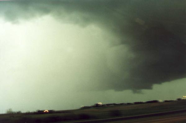
Gust front tentacles southwest of Amarillo
|
The Canyon
At the same time, another storm to the southwest of the Oldham County cell
was firing up between Bushland and Canyon in Randall County and moving toward metropolitan
Amarillo. The tornado warning came quickly and we moved south to intercept the
storm. We were out of radio contact with Glenn at this point and assumed he had
committed to the northern storm. Dave and I went through Amarillo along with pea to
marble hail on 1541 and then west on another small road where we set up shop in a church
parking lot. We were looking up at the side of the updraft tower that stretched to
cosmic proportions, a completely overwhelming, exciting and terrifying sight to me.
Dave and I agreed that we had to get out and photograph. The inflow began to howl
and an area of pronounced rotation developed to our immediate west. The rain and
hail shaft were inbound, however, and this storm was already famous for its hail: Dave
Fick reported later that his relatives who live about five miles west of Canyon, Texas
received baseball hail from this storm. We continued south.
Later, we caught up with Glenn and took a gorgeous drive through Palo Duro Canyon in half-hearted pursuit of the
now well-evolved squall line. The canyon was monstrous and seemed to try to engulf
the storms that moved slowly above. Even the powerful mountains of thunderstorm
energy were taxed to match the majesty of the mighty canyon, and the lightning hurled at
the jagged rock formations was a pitiful effort by the weaker of these two natural,
inanimate predators. It was almost sunset.
In Claude, Texas we called it a chase and photographed the dramatic mammatus below.
Dave was required to return his rental car and began the long journey to Oklahoma
City, vowing to return for more action the next day if the setup looked good. Glenn
and I headed back to Amarillo to find a room.

The end of the road and a great show
|
|
The models disagreed on the eastward movement of the dryline,
but the RUC hadn't done me wrong yet with this particularly difficult feature, and it
became apparent that old outflow would be the focus for storm initiation.
Boundaries were moving south towards Lubbock and we hoped to catch the wave and ride it to
chaser merriment. Winds north of the outflow boundary were from the
north.
We analyzed another target of CAPE near Lubbock according to the RUC, ETA and
MM5 in addition to good convergence from the surface through 850mb and the divergence
aloft pointed towards Lubbock for today's target. When we left Amarillo, Lubbock
reported partly sunny skies. As we moved to the south of the boundary that the
Amarillo office was describing now as a cold front, we noted that winds shifted out of a
southerly direction. This was very exciting to me, as I could imagine the sort of
convergence piling up where north winds behind the front and southerly winds ahead of it
would meet. I thought about the dryline, and hoped that it might help too by
creating a convergence corner of sorts at the intersection of it and the outflow boundary.
It could be a big day I thought as we pulled into Lubbock and searched for a place
to find data.
As we reached town, Glenn Dixon noticed a
well-formed storm to the northeast and commented that it already seemed to have a
backsheared anvil and an overshooting top. Here's another storm, I thought, just
like yesterday--trying to lure me into some distant, less-favorable environment. I
remember specifically telling Glenn: "I don't think I'm that impressed with it
yet." That would not be my last mis-judgement of that storm before the day was
done. The data check confirmed that the convergence along and ahead of the outflow
boundary was great, and looked to get even better. The instability was in place with
steep lapse rates in the mid-levels, which made me wonder if the cap wasn't too weak here.
This should have been another red flag to me to chase anything isolated that popped
up this day.
I decided that the area to the northwest of Lubbock, near Littlefield, should be
ideal for later initiation along the outflow boundary. Just as I was leaving the
table, Steve Miller sent an email to
Glenn and I, telling us that the storm Glenn spotted earlier was beginning to propagate
southeastward along a boundary of its own. "I suggest y'all take after
it," he wrote. I certainly didn't disagree with Steve, who is not only a better
forecaster, but also a far more experienced observer of storm tracks and behavior after
initiation, which some people may not realize is nearly a separate discipline, but just as
vital to success in stormchasing.
I was so completely sold on my new target area that I went to Littlefield
anyway--feeling very uneasy about the decision and justifying it on another level by
telling myself that I probably could not have caught the storm that now warranted a severe
warning in Briscoe County. Listening to my entries on the mini-recorder at this
point, the indecision is palatable. I was uncertain enough to call Dave Fick, who
was headed south from Amarillo and who planned from an earlier phone call to meet me in
Littlefield, and tell him about Steve's recommendation. Not only was he in a great
position to catch the storm, being near Plainview at this point, but I thought he should
know Steve's opinion, since I was now considering my decision to be somewhat on the
fringe. Glenn Dixon was also headed for the Floyd county storm.
Lubbock In My Rearview Mirror
Littlefield, Texas has a population of 7409. Probably very few of them
were aware that the storm about 60 miles to the east now had prompted severe warnings in
Floyd County and fewer still might have wished to be there. Towers were going up in
every direction around me, and falling over just as quickly. They were so numerous
it was hard to see any single updraft gaining dominance. I drove around Littlefield
like a pirate, trying to peer through the clouds for the storm I hoped was forming.
At 4:30, Dave Fick called from the Floyd County storm which moved so slowly that
the guys could have chased it on foot, to tell me that there was real rotation and inflow
here and I should come quickly. I looked on the map and incredibly, the storm was
still only 60 miles or so away. There was a tornado warning for it in Floyd
County. As I headed east on 54 to catch my friends and their storm, my area lit up
like a Christmas tree. Yes and I was glad, because storms to my west would not only
be easier to intercept, but I would meet them as they were young, and not after hours of
maturity as would be the circumstances with the Floyd County storm. The first
warning was out for Yoakum County on a storm near Plains, then Cochran County and
north. As I was already as far east as Spade, I went south from there on 168 to
Snyder and then west on 114. I stopped outside Levelland and watched the storm to
the southwest, which was less than impressive at this point. I listened as the
Lubbock spotters talked in awed tones about the Floyd County storm, which was headed for
Crosbyton. Slowly.
I moved east toward another developing storm in northern Lubbock county. This
HP beast wrapped up quickly, and began rotating with little warning. On the south
side of the storm, a funnel spun up, white and narrow and began to descend. I
couldn't believe my eyes since this storm had formed just moments ago. There
was no visible evidence of contact with the ground and as I regained my sense of my
surroundings, I realized that all the spotters were to the east or well southwest of the
storm, and I was the only person who had seen this funnel. Not knowing the tone to
the local repeater in use at that time, I was unable to open the machine and report the
funnel. I don't want to go into a diatribe about this here since it justifies a
separate essay. So again, for the reader's full comprehension: I was unable to
report the funnel in metropolitan Lubbock, Texas because of the tone on the repeater. As Vonnegut would say, think about that.

Wall cloud northwest of Lubbock
|

Rotating wall cloud in metro Lubbock
|
I knew now that this Lubbock storm was my date for the
evening and I wanted to score right away. I went north to the loop and crawled along
the roadway moving northeast, keeping the southeastern flank of the storm well within
view. Another wall cloud formed, large and black, slowly beginning to rotate.
I couldn't comprehend this becoming a tornado, and didn't want to try. Still, the
nervousness in the voices of these leathery, veteran Lubbock spotters made me realize that
this was a potentially unpleasant scene. Soon this feature broke apart, and the
large core of rain moved closer to my position. I continued northeast on the loop,
planning to get out on 82 Eastbound, keeping me ahead of this storm, and, conveniently, in
a decent position to go intercept the Floyd County storm, which was on its third or fourth
tornado warning by now.
At the intersection of 2641 and Martin Luther King Boulevard at 6:32 PM, I
watched another wall cloud form directly over the Lubbock International Airport grounds.
The inflow was stiff and the rotation tight as the storm seemed to be pulling
together for some large, sudden burst of energy. It was gathering steam and moving
east. I broke onto Highway 82 and went east a few more miles to get a better vantage
point. Just as quickly as it took me to move a few miles, the mesocyclone had become
rain-wrapped, and the storm exhaled cold air in a fury that bent back trees and sent small
items flying across the road. I moved quickly to stay ahead of this outflow and soon
found myself face to face with another angry beast.

Mothership meso in Lubbock while
needle funnel tries to emerge from wallcloud
|

Dissipating wallcloud over Lubbock Airport
|
A Storm Spurned
The Crosbyton Fire Department reported a tornado on the ground nine
miles north of Crosbyton. I was going towards Crosbyton and into the teeth of the
famous Briscoe/Floyd/Crosby county storm that I had avoided for so long. It seemed
as fate that we met finally this day, with the storm marching so slowly--painfully,
hypnotically bearing down on Highway 82 from the north. I was racing east on 82, and
saw the hail shaft out in the field to my north. It looked to be completely
stationary! I couldn't believe it, and the more I was convinced I might actually
beat the storm and get east of it, the faster I went. No, there were no good options
to the south. It was me and the train. Race to the crossing. What
happens to the loser? I had no interest in finding out.
At 7:00 PM, outflow blasted out of the north, pushing my truck towards the ditch.
Get stuck in there and I'll catch your ass. I fought the wheel to stay on the
road. Where was this alleged tornado? What direction was it going? Was
it here, there, anywhere? Everything seemed to be rotating above me. I watched a
funnel form, spin and dissipate to the north. There were so many storm features at
the same time that I was overloaded, and shut down everything expect my focus on driving
as fast as safety would allow, and as safely as a speeding demon could. I could see
the sunshine to the east--get out from under the anvil and everything will be fine.
The hail caught me and banged away at the truck with marble and pea size
artillery. Still, the tremendous outflow blasts were a larger concern, and the
stability of my very-high profile vehicle. Finally, I emerged from the maelstrom and
soon afterwards, heard the comforting sounds of Glenn and Dave chatting on the radio.
They were surprised to hear from me. So was I.
Dave and I went east and then South on 70 towards Spur, paralleling the massive
meso of the now completely HP storm, and had a front row seat for this impressive display
of storm-scale rotation and howling inflow, which Dave measured at a peak of 38mph.
The storm was now much better behaved, and if it were not for the very poor contrast, we
certainly would have had some stunning pictures of the well-sculpted storm base.
The rest of the chase was a retreat. The storm merged with another cell to
the south and a squall line was taking shape. We broke out onto Interstate 20 and
stopped a few times to look at radar images and try to find some dinner. The
tail-end charlie continued to rage, exhibiting a hook echo near Colorado City, where
baseball to softball hail and a tornado on the ground were reported. We stopped at
Snyder then fled. We stopped at Sweetwater and ran east some more, all the way to
Abilene, where we set up camp at a truck stop and ate dinner watching the storm on radar
and estimating its position relative to our food. Glenn and Dave replayed some great
video of the tornado they caught near Daugherty, and Dave also had some impressive
gustnado footage.
The worst convection passed to our south, and soon the storms lost intensity
with the sunset. Widespread flooding took place that night and the next day, as
another squall line came marching towards our hotel in Abilene early in the morning.
I had seen quite enough and headed back to Denton. Dave lit off for Houston, talking
about tropical funnels and hurricanes to come. Glenn and I drove lazily east,
encountering Steve Miller and Blair Kooistra along the way as they headed out to Midland
for another adventure.
[Author's note: Thanks to Glenn Dixon for the use of his laptop and
GPS directions and to Dave Fick, for his chase reports, his cool little TV in the backseat
and that amazingly helpful flashing yellow light. I gotta get one of those!] |