|
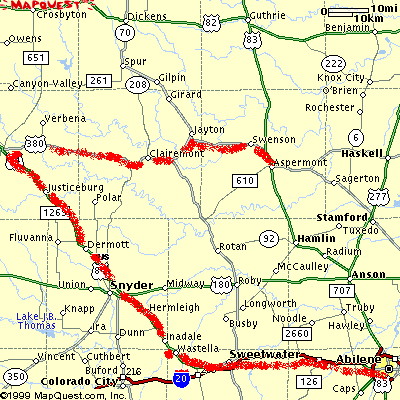
Chasing Wall Clouds: April 29Web Posted May 15, 2000 11:00 PM Sometimes it takes a real effort to avoid tornadoes. Certainly when a good forecast lands you in the right place at the right time, it's a real challenge to steer clear of the main attraction of the storms, particularly the long-track, visible variety. Here's the story of how we did it. We were excited about the potential for an old fashioned dryline setup on 4/29/2000 and left Dallas early for Abilene, where we stopped for data. Clint Norwood, a photographer from Dallas, chased with me and we were soon joined by Eric Nguyen and Eric Ware, both OU Meteorology students from Norman riding in Eric's car. |
| Noticing an increasing area of moisture convergence to the north, we continued
west to State Road 84, where we went north towards Lubbock. Three long-track dust
devils spun up in the fields to either side of us, West Texas dirt spinning playfully over
the open country. Driving north on 84 between Justiceburg and the 380 intersection,
a tower exploded to our west among oil fields with no roads at all. We
watched a rounded updraft base drift east over 84 right in front of us, into another area
without roads to our east. Our only choice was to move quickly north to 380 and move east
on that road as fast as we legally could. When we caught the storm again, we filmed several collar clouds on the base of this elevated LP storm. That storm died and another formed east of it, an odd storm that slowed and became nearly stationary, updrafts regenerating in the same place, the inflow sustained continuously. Dave Brown, Shane Adams and some others watched with us as this cell sat still for nearly thirty minutes. Clear banding around the updraft base left no question the storm was rotating at least in the mid-levels, and persistent lowerings demonstrated that the storm might have had more luck with better boundary layer moisture or upper level support. I had been counting on an early arrival of the upper level jet streak to compensate for poor moisture values at the surface, but the nose of the jet hadn't arrived yet. We would learn the power of that feature soon enough. |
|
|
|
We decided to
stay in Aspermont, hoping for food and a clean room. We talked to Gene Rhoden on the
radio as he headed back to Dallas. We found a small hotel next to restaurant that
was about to close. Great chicken fried steak and chocolate pie made us all sleepy,
and we paid the bill and wandered back the hotel just a few yards away.
|
|
| April 30, 2000:
If Only We'd Made Olney
We woke up excited at the prospect of already being in a great spot. I sent the following email to the Storm-Chase newsgroup after having a solid breakfast of pancakes and coffee at the diner next to the motel: "I'm in Aspermont now, as we stayed here after last night's chase, which had a
spectacular ending with the rotating storm over Aspermont that threatened the town with an
ominous wall-cloud. Waking up here this morning, I can't find a reason to go
anywhere. With a dryline punching in and an outflow boundary sagging south from the
OK convection ongoing attm, I think by max heating we'll have excellent convergence right
here, in addition to the most favorable directional profile. Upper level dynamics
are significantly improved with the RUC's jet depiction punching in later. ETA is
underforecasting moisture and thus CAPE again, in my opinion, and the RUC is probably
overdoing it. |
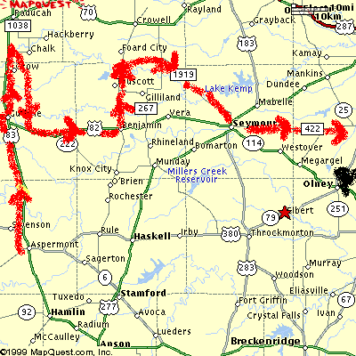 Path of Chase on April 30, 2000 Later that morning I wrote this: "Well, SPC describes my outflow boundary as moving north rather than south. So, I suppose while Aspermont is still in an excellent target area, the ideal area may be slightly north, but not too far. We're going to drift slowly north and see if we can pick up the boundary on Eric's marine radar. We're not overly hopeful, but it's something to do. Going to try a hand analysis if we can remember how, and try to hunt this boundary. Target shift towards Guthrie and Paducah. :-)" Turned out to be a good choice. We observed a storm firing to our Northwest as we reached Guthrie, but the crown looked fibrous and weak, and we risked taking the time for a quick radar update by using the phone line in a local gas station. We were out of NOAA range, at least for the radios on the two vehicles present, and nobody had a cell signal by which to make a call. My instinct was to stay put, and not chase the storm which appeared to be well to our north. The dryline was coming, and with the unstable airmass to our east, we all assumed there would be more storms soon enough. Unfortunately, technology can change your perspective. The radar image showed a developing supercell to our northwest, just south of Childress. We went after it. |
|
|
| Between Guthrie and Paducah, a significant wall cloud rotated in the notch of this mature supercell. We saw dust whirls on the ground, indications of what may have been a brief spin-up. With no photographic evidence to prove this--Eric's camera was jammed and stills taken by Clint and I are inconclusive--I can't call it a touchdown, though in my heart of hearts I think it was. Anyone else who may have been there at the time, feel free to email me with your opinions. The two Erics raced north, planning to get ahead to an east road and stay ahead of the storm. With baseball hail reports and having waited a moment too long, I opted to go back south, which Eric eventually did after the road he planned to take wasn't there. Clint and I raced south back to Guthrie, then east on State Road 82. Here, something remarkable happened. I managed to secure and maintain a cellular modem connection to the internet while we were moving for over twenty minutes. I downloaded radar and warning text as we maneuvered around the southeast corner of the storm. The radar showed a line of developing cells to the east. I noticed the southernmost cell looked more isolated than the others, but it looked like a squall line waiting to happen. That southernmost cell would become mature in Throckmorton County, and eventually drop the long-lived and highly visible Olney tornado. The storm to our north, the one we were cornering, was in full maturity, a beautiful hook echo in Foard County. At the time, it seemed like a no-brainer. |
|
| North of Benjamin, we had a
great view of the base, and more persistent lowerings. Since there were dozens of
chasers and DOW trucks, I know I wasn't the only soul to miss Olney. Soon our storm
was dying, and word came of a tornadic circulation in the Throckmorton County storm.
We drove through at least thirty miles of precipitation from this storm before we
got in position to move south along the eastern flank. By that time, there wasn't
much left to see, although tornado warnings continued for another rotating wall cloud
which we watched for some time. Thinking the chase was ended, we retired to
Jacksboro to a large chaser convergence meal at The Village. During the meal, someone noticed the lightning frequency had increased on the storm approaching from the west. Checking a radio, we learned that another tornado warning was in effect, and like a scene from a bad movie, at least ten chasers scrambled to scarf down burgers and pay the check, and the caravan was on the move again. We raced east on 380 to get out ahead of the surprise cell, and then south on 51 to gain a better view. Soon the storm became outflow dominant and the line formed, an impressive gust front marching toward the DFW metroplex. We went back north on 51, planning to take 380 back towards Denton. The storm caught us on 51, and powerful straight line winds of between 40 and 50 knots rocked the truck back and forth on the highway. The cells died as they reached Denton County, and the long chase was ended. |
|