
3:50 PM Supercell forming near Eldorado, OK.

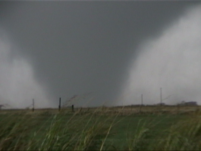
4:53 PM Tornado D1 west of Hobart.

4:54 PM Tornado D1 west of Hobart.
by Amos Magliocco
Robert Hall and I left Denton, Texas around 1:00 PM targeting Quanah to Altus. The first tornado we saw moved from Hobart at about 4:50 PM to near Gotebo, OK. This is Tornado D1 or the "Hobart Tornado" in OUN's Tornado Table for the event. Our second touchdown at 5:36 PM was west of Mountain View, OK, which is west of Anadarko by about 15 miles. This tornado, designated D2, or the "Gotebo/Mountain View Tornado," began as a breathtaking, multi-vortex with tall, well-separated vortices describing a large circumference around the center of circulation, all of which were on the ground. This occurred two miles west of Mountain View and just north of State Highway 9. But the tornado wasn't nearly finished after this stage, continuing on a 13 mile damage track over thirty minutes. This tornado was rated F3 by Surveyors from the National Weather Service.
From Norman NWS Damage
Survey:
HTTP://WWW.SRH.NOAA.GOV/OUN
(ALL LETTERS UPPER CASE)
DAMAGE PATH #5 (Tornado D2--"Mountain View Tornado"):
1 MILE NORTH GOTEBO TO 7 MILES NORTH NORTHEAST OF MOUNTAIN VIEW
LENGTH: 13 MILES, MAX WIDTH: 1/4 MILE
THE TORNADO WAS MULTIPLE VORTEX AS IT FORMED AND MOVED WEST THROUGH
NORTHWEST OF MOUNTAIN VIEW, BASED ON EYEWITNESSES. SIX PERMANENT DWELLINGS WERE
DESTROYED (5 HOMES, 1 SCHOOLHOUSE), ALONG WITH NUMEROUS BARNS AND OUTBUILDINGS, AND ONE
BUSINESS. F2 OR GREATER DAMAGE WAS CONFINED TO A 2 MILE STRETCH NEAR/ALONGROUTE 115,
FROM ABOUT 2.5 MILES NORTH MOUNTAIN VIEW TO AROUND 4 MILES NORTH NORTHEAST OF MOUNTAIN
VIEW, AND AN ISOLATED FARM 6 MILES NORTH NORTHEAST OF MOUNTAIN VIEW. THE TORNADO
INITIALLY MOVED EAST NORTHEAST, THEN TURNED GRADUALLY TO THE NORTHEAST BEFORE TURNING MORE
SHARPLY TO NORTH NORTHEAST AFTER CROSSING STATE ROUTE 115. THE TORNADO THEN NARROWED AS IT
TURNED SHARPLY BACK TO THE EAST NORTHEAST BEFORE DISSIPATING. INJURIES/FATALITIES: 1 MINOR
INJURY
MAX DAMAGE RATING: F3

5:23 PM Funnel near Gotebo, OK.

5:36 PM Tornado D2 touches down 3.5 miles west of Mountain View, OK.

Tornado D2 West of Mountain View / North of State Highway 9.

5:37 PM D2 Multi-vortex begins to take shape.

Zoomed on an individual vortices of Tornado D2.

5:38 PM Multi-vortex D2 west of Mountain View.

5:39 PM Multi-vortex D2 west of Mountain View.

5:40 PM Multi-vortex D2 west of Mountain View.

5:42 PM D2 becomes a wedge 2 miles wsw of Mountain View.

5:42 PM Wedge takes shape 2 miles wsw of Mountain View (Tornado D2).
5:43 PM Wedge takes shape 2 miles wsw of Mountain View (Tornado D2).

5:44 PM Wedge trying to go multi-vortex again at the surface (Tornado D2).

Debris wrapping around Tornado D2.

Here's a still of the Mountain View F3
taken by my chase partner Rob Hall