

Our initial target was the nose of what we expected would be a vigorous dryline bulge. We hoped storms would fire ahead of this lift and traverse the warm front along or just north of I-70. Like everyone else, we were disappointed by the quality of boundary layer moisture and by the apparent weakness of the impulse that had tempted us to chase under a ridge in the first place. Early RUC forecasts for midlevel winds were discouraging, but we checked profilers throughout the day and never gave up entirely on the idea that something along the boundary could see improved SR flow if it anchored to the front.
We wandered about and encountered Scott Eubanks on his first day of chase vacation, and enjoyed a lazy dinner in Wakeeney before turning back east with the intention of reaching I-35 and our route home. The lack of cumulus and consistent forty degree dewpoint depressions in central Kansas had convinced us it was time to turn south. Along the way, all three of us were either sending text messages or engaged in cell conversations about the bust when a rounded updraft base appeared north of the highway.
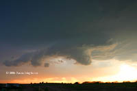
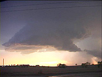
The base was elevated but compact and over the next twenty minutes a core developed then split away. We met Ryan McGinnis and Darren Addy at this point and watched the slowly-developing storm spit intermittent CG’s that ran us back into our vehicles. Afterwards, the remaining updraft base looked much like it had earlier near the highway, a smooth underside with a signs of circular organization. Our inflow picked up substantially and the storm developed a collar cloud that turned while scud condensed and attached to the center of the elevated meso. Within ten minutes, the storm produced a large, blocky wall cloud that rotated lazily while two elevated funnels formed around the periphery of the collar cloud.
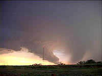
After the first occlusion, we followed the storm a few miles south (mean forward motion was probably around five knots!) while looking in amazement at a new, larger wall cloud and associated tail cloud near a dark and well-defined rain foot. When we stopped, the tail cloud grew very low. Our best guess is that this feature was 1-1.5 km long and very vertical, nearly reaching the ground. While it's important to emphasize that this was not tornadic or even rotating with any vigor, it was nevertheless interesting for illustrating the elevated nature of the storm and how much trouble it went through to tap into boundary layer moisture and higher RH air along the stationary front.
Soon the outflow-dominated fate of this cell befell our last attempt at organization and the final wall cloud was much more elevated and broad. By 0130z, the storm suffered both from a lack of midlevel winds and contaminated inflow courtesy of convection to the south. With pictures and video we hadn't anticipated capturing, we turned for home around 0200z. A clear-sky bust became a fun and unexpected chase with a great looking supercell.