
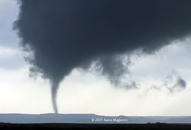
~2355z tornado crossing the Prairie Dog Town Fork of the Red River on March 28, 2007
28 MARCH 2007: TEXAS PANHANDLE TORNADOES
~2355z tornado crossing the Prairie Dog Town Fork of the Red
River on March 28, 2007
|
(These are video captures from my chase on March 28th in
the Texas Panhandle, easily the best March chase of my life. My chase
partner Eric Nguyen and I chased this event and witnessed around six tornadoes
between Silverton and McLean, from 6:29 PM until we broke off the nighttime
stovepipe about 8:25 PM. |
|||
|
|
|||
|
|
|
||
| Our first tornado took us by
surprise, appearing in the distance approximately 1 mile northeast of
Schott Mountain, by our estimate. We observed this from one mile
south of Brice, Texas between 2303z and 2305z. |
|||
 2339z |
 ~2345z |
 ~2348z |
 ~2349z |
 ~2354z |
~2355z |
 ~2356 |
 ~2356z |
 ~2358 |
 ~0z |
 ~0005z |
|
| This tornado above began at the top
of a ridge (from our vantage point) around 2339z. It morphed and
shifted and emerged in sunlight then took a dip in the Prairie Dog Town
Fork of the Red River, encircling itself in water and red, sandy loam.
Gorgeous! Tornado lasted until 0010z with an extended rope-out
stage. |
|||
 0057z |
|||
| Who belongs to this tornado?
Appears to be the beginning rope-out stage of a rather impressive
tornado. I
would place it at the intersection of 291 and County Road 0, or approx 8
miles northeast of Clarendon. I don’t have particularly high confidence
in this location, however, since we were moving and didn’t call out the
spot. The tornado lasted only a few minutes from the time we spotted
it. No idea when it had started. |
|||
 0102z |
 0104z |
 0105z |
 0112z |
 0114z |
 0114z (RFD blowing into eastern meso) |
 0115z (RFD blowing into eastern meso) |
 0117z |
 0119z |
 0120z |
||
| The famous McLean "west" tornado as
it gets rolling and lumbers northeast from around the SR 291/CR1
intersection in Donley County (about 11 miles south of Alanreed) up to
I-40 between 0102z and our last sighting around 0120z (tornado continued
beyond this time, however).
McLean "west"
lifted and dropped several times, but we confirmed it again at 0109z
about 6 miles sw of McLean. At 0113z we saw golf ball hail on SR 273
when we ourselves were about 7 miles south of McLean.
At 0114z, Eric Nguyen saw the first wisps of a
new tornado to our immediate EAST, confirmed by OU grad student Bob
Fritchie. We didn't see this eastern tornado
again and cannot confirm anything else about its evolution or path. At
0115z we experienced strong RFD approximately
4 miles south of McLean, likely associated with the
meso/developing tornado to our east, which raked the eastern edge of
McLean and struck a remote weather station. At 0119z
we spotted the “McLean west” tornado again when
it was a stovepipe and very close to I-40. |
|||

