
10 m south of Hill City, Kansas ~0005z May 22, 2007 (YouTube clip and video grabs under report below)


In Garden City I noticed the dryline bulge had pushed into southwest Kansas and a field of low cumulus formed in the confluence zone ahead of the boundary. Scott Eubanks and I moved northeast and observed enhanced cumulus in southern Scott County. Scott remarked that the rapidly exploding tower would probably wind up in Nebraska before the day was finished. He was right. We moved east on SR 4 and north on CR 1452 to maintain position on the impressively striated supercell.
We continued up to Interstate 70 and moved north out of Collyer on St. Peter Road. The storm nearly produced a tornado west of St. Peter while I had a great shot composed with an oil derrick in the foreground. The detailed vault emerged from the rain with a textured surface like an ice sculpture, deep grooves along the crown and a circular updraft base. It was one of those rare storms where you could discern the rotation of the entire cell with the naked eye. A breathtaking sight.
Yet it seemed high-based and after the show near St. Peter, our tornado prospects dimmed. I wasn’t sure where we were relative to the front or any boundaries and didn’t expect much more than we’d seen: brilliant structure and a well behaved supercell. We traveled dirt roads between St. Peter Road and SR 283.
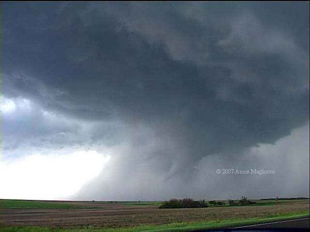
From approximately ten miles south of Hill City on 283, near Togo, more great structure emerged from behind a rain shaft and rapid cyclonic shear at cloud base gave us hope. We didn't wait long. About 0005z, a tornado touched down five to seven miles east of St. Peter.
This storm was one of the finest I’ve seen in
years. It developed the air-brushed
appearance of the plains'
most beautiful convection. The tornado was a
bonus. I headed back for Texas soon after the long rope-out
stage, chatting with Scott Blair on the radio as he
drove home for a
midnight shift at TOP NWS.


All imagery © 2007 Amos Magliocco